Woodlands Research
Woodland Monitoring Survey
|
Under Article 17 of the EU Habitats Directive, Ireland (through NPWS) has an obligation to monitor and assess the conservation status of Annex I habitats, including woodlands. This Woodland Monitoring Survey is the first monitoring survey of Annex I woodlands to be carried out in Ireland. Between 2011 and 2012, over 100 samples of Annexed woodland habitats, ranging in size between 4 and 10 ha, will be surveyed across Ireland. Condition and conservation status will be assessed by comparing measured indicators with target threshold values. The results of the survey will feed into Ireland’s reporting input under Article 17 and enable an assessment to be made of the conservation status of four Annex I woodland types found in Ireland: Old sessile oak woods (91A0), Alluvial forests (91E0), Yew woodlands (91JO) and Bog woodland (91DO). The first 2 habitats are being monitored by BEC Consultants and the last 2 habitats by NPWS staff. |
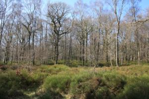
Vale of Clara (Photo: NPWS) |
National Survey of Native Woodlands
This national survey of native woodlands mapped all stands of native woodland >1 ha. A stratified sampling procedure was used to survey 1,320 sites in detail. At each site the details of the plant species, vegetation, forest structure and physical parameters were recorded, including 1,667 relevés. Existing published and unpublished information on stands was incorporated into a large database.
The area under native trees is about 133,000 ha, although the area which would be considered as native woodland is probably <100,000 ha. 50% of stands are <6 ha and only 3.3% are >50 ha. The greatest density of native woodlands is found in Waterford, Offaly and Wicklow and the lowest in Dublin, Louth and Carlow.
4 major woodland types have been identified: sessile oak – woodrush (Quercus petraea – Luzula sylvatica), ash- ivy (Fraxinus excelsior – Hedera helix), alder – meadowsweet (Alnus glutinosa – Filipendula ulmaria) and birch – Molinia grass (Betula pubescens – Molinia caerulea). 22 subtypes have been recognised including yew (Taxus baccata) woodland and willow (Salix spp) woodland. A conservation score has been calculated for each of the woodlands surveyed. This score allows the relative conservation value of each site to be assessed, and provides baseline data which can be used for monitoring sites in the future. A threat score was also produced to give an indication of the threats posed to woodlands.
A Summary of findings of NSNW ![]() [60KB] main findings of the research is available, or you can download the two volume report below:
[60KB] main findings of the research is available, or you can download the two volume report below:
- Perrin, P., Martin, J., Barron, S., O'Neill, F., McNutt, K. & Delaney, A. (2008) National Survey of Native Woodlands - Volume 1 Main Report
 [2.98MB]. Unpublished Report to the National Parks & Wildlife Service.
 - Perrin, P., Martin, J., Barron, S., O'Neill, F., McNutt, K. & Delaney, A. (2008) National Survey of Native Woodlands - Volume 2 Woodland Classification
 [5.44MB]. Unpublished Report to the National Parks & Wildlife Service.
Provisional inventory of ancient and long-established woodlands Following the main woodland survey a provisional inventory of ancient and long-established woodlands was undertaken. Ancient woodlands are defined in Ireland as areas which have been wooded since 1660. Long established woodlands are sites which have been continuously wooded since 1830, when the 1st edition Ordnance Survey maps were published but for which no documentary evidence has been found that they date back to 1660. Coppice_ring_Maryfort Coppice ring, Maryfort, Co. Clare (Photo: J. Cross) Possible ancient woodlands (PAWS) and long established woodlands (LEWS) were identified from documentary and archaeological evidence and a subsample was analysed for floristic data in an attempt to identify possible indicator species. A provisional list of Ancient Woodlands (AW), PAW and LEW sites was drawn up. AW/PAWS and LEWS show evidence of extensive coppicing, often have large coppice stools and earthworks and contain significantly more vascular plant species than more recent woodlands. A preliminary list of 29 ancient woodland vascular plants which are significantly more frequent in AW/PAWS has been compiled. These tend to be species with poor colonising abilities. NB. The presence of one or even a few of these species is not necessarily an indication of AW/PAWS: a suite of species is a much stronger indicator. Details of the survey can be found in: Perrin, P. and Daly, O. (2010). A provisional inventory of ancient and long-established woodland in Ireland. Irish Wildlife Manual 46. PDF_icon [10,462KB] National Parks and Wildlife Service, Department of the Environment, Heritage and Local Government, Dublin, Ireland.
Long-term monitoring of the impacts of grazing in native woodlands
Following the main woodland survey a provisional inventory of ancient and long-established woodlands was undertaken. Ancient woodlands are defined in Ireland as areas which have been wooded since 1660. Long established woodlands are sites which have been continuously wooded since 1830, when the 1st edition Ordnance Survey maps were published but for which no documentary evidence has been found that they date back to 1660.
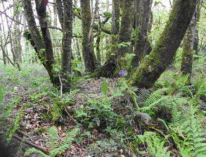
Coppice ring, Maryfort, Co. Clare (Photo: J. Cross)
Possible ancient woodlands (PAWS) and long established woodlands (LEWS) were identified from documentary and archaeological evidence and a subsample was analysed for floristic data in an attempt to identify possible indicator species. A provisional list of Ancient Woodlands (AW), PAW and LEW sites was drawn up.
AW/PAWS and LEWS show evidence of extensive coppicing, often have large coppice stools and earthworks and contain significantly more vascular plant species than more recent woodlands. A preliminary list of 29 ancient woodland vascular plants which are significantly more frequent in AW/PAWS has been compiled. These tend to be species with poor colonising abilities. NB. The presence of one or even a few of these species is not necessarily an indication of AW/PAWS: a suite of species is a much stronger indicator.
Details of the survey can be found in: Perrin, P. and Daly, O. (2010). A provisional inventory of ancient and long-established woodland in Ireland. Irish Wildlife Manual 46. ![]() [10,462KB] National Parks and Wildlife Service, Department of the Environment, Heritage and Local Government, Dublin, Ireland.
[10,462KB] National Parks and Wildlife Service, Department of the Environment, Heritage and Local Government, Dublin, Ireland.
|
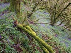
Woodland scene with bluebells (Photo: NPWS) |
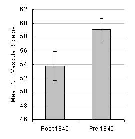 |
Comparison of the mean number of vascular plant species found in woodlands, relative to woodland age.
|
Long-term monitoring of the impacts of grazing in native woodlands
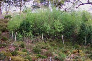
NPWS has worked for many years in close association with Trinity College to examine the impact of grazing on the vegetation and tree regeneration within the Killarney and Wicklow National Parks. Exclosures have been erected within these woods to exclude large herbivores (mostly deer and sheep) in order to gain a better understanding of the impact of grazing on woodland ecosystems and the interactions between herbivores and the vegetation. Some of these exclosures have been monitored for over 40 years and constitute a uniquely detailed long-term record of change and continuity in native woodland vegetation.
The results to date show that in the absence of grazing prolific regeneration of native tree species can occur but that in general grazing levels are too high in these woods, despite culling and fencing. Currently, a detailed research study (partly funded by NPWS) is underway on the impacts of grazing on plant diversity and tree regeneration. The study will be completed in 2013.
| Exclosure in Killarney National Park showing impact of excluding deer (Photo: J. Cross) |
 |
The Conservation of Juniper formations in Ireland
Juniper is a coniferous shrub native to Ireland with an extensive but discontinuous distribution. Juniper belongs to the Cypress family, and has two subspecies native to Ireland: the common juniper (Juniperus communis ssp. communis) and the prostrate juniper (Juniperus communis ssp. nana).
Juniper is found in a wide range of habitats but grows best in thin nutrient-poor acid or alkaline soils, from sea level to high montane environments. Juniper is found throughout Ireland on varying geology and terrain including limestone pavement, calcareous grassland, acidophilous heath communities and sand dunes.
Within Ireland Juniper is recorded from 108 10 km squares. One of the main perceived threats to Juniper populations is the large proportion of old, senescent bushes and lack of recruitment from seed. Establishment of seedlings has been shown to be negatively affected by both over-grazing, undergrazing and climatic factors. Overgrazing may present a particular problem, particularly for those formations occurring in montane and rough pasture hillsides where effective fencing is problematic. Coastal populations tend to be out of the reach of many grazing animals but their persistence on cliff faces exposes them to windthrow and, consequently, many of these populations comprise limited numbers of stunted trees. These threats to seedling establishment are further exacerbated by low levels of seed viability coupled with limited dispersal.
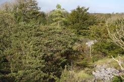 |
| Juniper formation (Photo: J. Cross) |
A national survey is nearing completion. The aims of the survey were as follows:
- To establish the distribution and extent of Juniper formations
- To determine the condition and future prospects of all Juniper formations
- To assess the conservation status of the habitat
- To propose management recommendations to ensure favourable conservation status is achieved
- To propose a monitoring prescription for this habitat type
 |
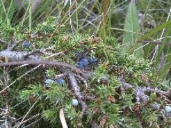 |
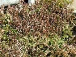
| Juniper Heath (Photo: C. O' Keeffe) | Juniper Berries (Photo: N. Kingston) |
Limestone Pavement Research
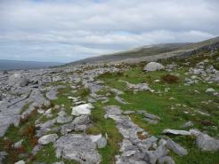
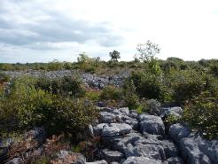
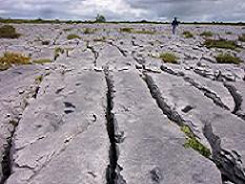
Limestone pavements were formed during the last ice age by the scouring action of the ice sheets as they moved along the landscape. Limestone pavement can occur in a smooth form with blocks of rock, called clints, separated by fissures or grykes, where soils accumulate, and in a shattered form where grykes are less frequent and vegetation is sparser. This morphology offers a variety of microclimates allowing the establishment of complex vegetation consisting of a mosaic of different communities. The vegetation in grykes is unusual as it is composed of woodland and shade species along with plants of rocky habitats. Limestone pavement is typically found in a mosaic with other habitats such as grassland, heath, scrub and woodland.
Limestone pavement (including the mosaic with grassland, heath & scrub) is classed as a priority Annex I habitat under the EU Habitats Directive. Ireland has the largest area of limestone pavement in the EU with over 31,000 ha found mainly in the west of Ireland. Counties Clare, Galway and Mayo contain the largest areas with the greatest concentration in the Burren region of Clare/Galway.
 |
 |
|
|
Black Head, Co. Clare (Photo: NPWS) |
Lough Mask, Co. Mayo (Photo: NPWS) |
A preliminary conservation status assessment in 2007 showed that the condition of many of the limestone pavements was unfavourable. Threats include rock removal, scrub invasion, changes in agricultural practices and development.
A pilot survey to re-examine the extent of pavement and to develop methodologies to assess the conservation status of limestone pavement and associated habitats in Ireland was completed in June 2009. It focused on six limestone pavement areas; West-Burren, Mid-Burren, East-Burren, Lough Corrib, Lough Mask, and the Bricklieve Mountains. Methodologies were devised to assess the conservation status of limestone pavement and the National Distribution map of Limestone pavement was revised and updated. The final report has been converted into an NPWS publication (Irish Wildlife Manual) and can be downloaded from here.
The results of this pilot survey, together with updated maps, have facilitated a national survey and monitoring programme that will cover all elements required to assess the conservation status of Limestone pavement in Ireland. In addition it will aid the identification of areas which may be suitable for designation as NHAs and assist in the rationalisation of SAC boundaries where required.
The final report of the national survey entitled “The identification of potential additional areas of limestone pavements and associated habitats for designation and a national assessment of their character and conservation status” will be completed later in 2012.
The main objectives of this project are as follows:
1. Survey of non-designated areas for potential designation
Using a combination of GIS, field surveys and other data, additional areas of limestone pavement and associated habitats will be identified, which may be suitable for designation. Special attention will be given to scrub/woodland covered pavement.
2. National baseline monitoring survey
Further to the 6 sites surveyed in the pilot survey an additional 20 sites will be surveyed across the range of limestone pavement in Ireland.The conservation status of limestone pavement and associated habitats at each site will be assessed. The monitoring protocol developed in the pilot survey of Limestone Pavement and associated habitats will be refined and updated as appropriate. The national conservation status assessment of Limestone Pavement and associated habitats will be updated, using all available data.
 |
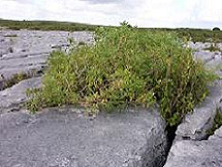 |
Limestone Pavement, The Burren, Co. Clare (Photos: John Cross)
Further information can be obtained from ecologic.consultants@gmail.com
Grike microclimates
Grikes are a unique and integral feature of limestone pavement. They provide a very specific habitat for a distinctive assemblage of organisms, including certain higher plants often associated with woodland and, in particular, invertebrates, which live in the sheltered environment. By virtue of their physical form they have a distinctive microclimate which impacts on the biodiversity. The plants and invertebrates found within grikes are sheltered from the changeable external climate and have become adapted to this specialised niche.
The interaction between the microclimate and biodiversity, however, is poorly understood and a better knowledge of the current and future microclimate of grikes will increase our understanding of grike ecology and their associated biodiversity. This niche may become inhospitable with the onset of climate change and the grikes may suffer changes in microclimate causing adverse effects on those species unable to adapt.
A research project entitled ‘The effect of form, position and future climate on grike microclimates in a limestone pavement - implications for biodiversity and geodiversity’ has begun and NPWS are contributing to the study of grikes in the Burren. It is hoped that the study will provide information that might assist in the appropriate management of the grike habitat.
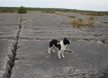 |
| Grikes, Sheshymore, Burren, Co. Clare (Photo: J. Cross) |
Further information can be viewed at www.limestone-pavements.org.uk
Members of the Scientific Unit can be contacted by e-mailing: natureconservation@npws.gov.ie

