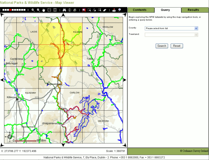
The Map Canvas
The Map Canvas is the main interactive workspace on the Map Viewer which initially contains the map of Ireland. It allows you to locate National Parks and Wildlife sites geographically. When you load the Map Viewer for the first time it displays the map of Ireland, this is the full Extent of the mapping available on the Map Viewer. Note: The Extent is the box that defines the area of a map being viewed. A Map Extent is defined in terms of the map coordinates comprising the corners of the bounding box, usually the lower left X and Y coordinates, and the upper right X and Y coordinates. Whenever zoom functions are performed, the current map extent changes to represent the current area being viewed.
It displays map themes that have been selected to best assist you in locating the desired Special Areas of Conservation (SACs), Special Protection Areas (SPAs), Natural Heritage Areas (NHAs) or Species data and these will automatically become visible at the most appropriate scales. For example, when you use the Zoom in tool you will see that the maps displayed change the more you zoom in and revert back as you zoom out. You can modify the themes that are displayed on the map canvas using the options in the Contents tab. You can turn on and off themes, refresh the map canvas and view the legend.
When you have zoom in on the location that you are interested in, the sites will be displayed automatically. You can use the tools in the toolbar to select and view details of the individual monuments, see Database Queries and Select Data for more details.
The Map Canvas also includes an overview map, located in the top left hand corner, this map will indicate where you are located on the main Map Canvas on the map of Ireland. The Overview Map also allows you to pan and zoom on the main Map Canvas by selecting an area in the Overview Map canvas. Using the mouse draw a box (indicated by the red outline) on the overview map canvas in the desired location. The Map Canvas will be refreshed panned and zoomed to a new extent indicated by the box drawn on the overview map. Note: The size of the box drawn on the overview map canvas will cause the main Map Canvas to zoom in or out as required.
The Map Canvas area is surrounded by eight arrows that point in different compass directions. You can use these arrows to pan (move to a new location on the map) in the direction required.
The Scale Information Pane
This section of the Map Viewer displays the current scale that you are at on the Map Canvas along with the coordinates of you mouse cursor on the Map Canvas.
The map scale is an indication of how far reality has been scaled down in order to represent geography on the Map Viewer. Map scale is the relationship between a unit of distance represented on the map and the same distance measured in the real world. The map scale is presented as a ratio (e.g. 1:2000). A bar scale is used on the Map Canvas to indicate the map's scale.
The coordinates of your mouse pointer are also displayed in this section. If you move your mouse around the Map Canvas you will see the coordinates change.
The Toolbar
Each tool in the Toolbar is outlined below with examples where appropriate.
Zoom Bar
This tool allows you to zoom in and out by a predefined scales factor by using a scroll bar. If you click one of the segments then the Map Canvas will zoom in or out as appropriate. Note that the Scale Information changes as you zoom in or out using the scale bar.
To zoom in or out using the zoom bar
- Move your mouse across the zoom bar until you identify the required scale.
- Click on the segment required. The Map Canvas is automatically refreshed and zooms in or out by the predefined scale factor required.
Zoom In
This tool allows you to zoom in to a narrower view on the Map Canvas. Two zoom in options are available in the map view, Single Click and Click & Drag.
Using the Single Click zoom in option
- Click the Zoom In button to activate Zoom In mode.
- Click the point on the Map Canvas where you want to zoom in. The Map Canvas is updated to display a map area that is zoomed in and centered on the point you selected.
Using the Click & Drag zoom in option
- Click the Zoom In button to activate Zoom In mode.
- Click to select the point on the Map Canvas and drag a box over the area you want to zoom in on. The Map Canvas is updated to display a map area that is zoomed in to the extent of the box drawn.
Zoom Out
This tool allows you to zoom out to a wider view on the Map Canvas. Two zoom out options are available in the Map Canvas, Single Click and Click & Drag.
Using the Single Click Zoom Out
- Click the Zoom Out button to activate Zoom Out mode.
- Click to select the point on the Map Canvas where you want to zoom out. The Map Canvas is updated to display the new map area zoomed out and centered on the point you selected.
Using the Click & Drag Zoom Out option
- Click the Zoom Out button to activate Zoom Out mode.
- Click to select the point on the Map Canvas and drag a box over the area you want to zoom out. The Map Canvas is updated to display the zoomed out map area. The amount that you have zoomed out is indirectly proportional to the size of your box, i.e. the smaller the box the greater the zoom out will be.
Pan
The Pan tool enables you to move your view space to a different location on the map, i.e. to pan the map. You can pan the map in any direction. There are two pan features on the Map Viewer, Click & Drag using the pan tool and the Pan arrows around the Map Canvas.
To pan the map
- Click on the Pan button to activate the Pan mode.
- Click to select a point on the map and drag the Map Canvas in the direction you require.
- Release the mouse to update the map to your newly defined extents.
Using the pan arrows
- Pan arrows appear as arrow heads along the Map Canvas frame. Click the Pan Arrow that indicates the direction you want to pan. The map is updated to the new extents.
Zoom To Previous Extent
The Zoom to Previous Extent tool is used to refresh the Map Canvas so that it reverts to the previous map view as displayed. The last 10 map views are stored for you.
To Zoom to Previous Extent
- Click the Zoom to Previous Extent button on the Toolbar. The Map Canvas is updated and reverts to the extent of the previous view.
Zoom To Full Extent
The Zoom to Full Extent tool is used to refresh the Map Canvas so that it reverts to the entire map view as displayed when you first opened the mapping application.
To Zoom to Full Extent
- Click the Zoom to Extents button on the Toolbar. The Map Canvas is updated and reverts to the extent of the view that appeared when you opened the Map Viewer.
Gazeteer Tool
The Gazeteer tool is used to allow you to zoom to the extent of a townland in a particular county.
To run the Gazeteer
- Click the Gazeteer button on the Toolbar. A form will open on the map viewer that will allow you to specify the county and townland required.
- Select the county required from the dropdown list of counties. The townland list will be refreshed with townlands in that county.
- Select the townland required from the dropdown list of townlands.
- Click Locate on Map to zoom to the townland or click Close to abort the search.
Identify
The identify allows you to identify NPWS sites on the Map Canvas. When you use the identify the map viewer will select all sites and species data that you have click on and display the details of these in the results area.
To Identify sites
- Zoom in to your area of interest on the Map Canvas.
- Click the Identify button on the Toolbar.
- Click on the location on the Map Canvas where you what to identify the sites. The Map Canvas will refresh with the sites and species grid highlighted and the information on these sites will be loaded in the results area.
Note: You can modify the themes that are identified on the Map Canvas using the options in the Contents tab.
The print option will allow you to create a print friendly version of the Map Canvas and legend of your current view. The print is designed for A4 Portrait.
To Print a map
- Click the Print button on the Toolbar. A new browser window will open with the Map Canvas and legend formatted for an A4 Portrait print. You can now print this from your browser toolbar as normal.
Database Query
This option will allow you to specify a combination of county and/or townland and to run a search against the database to return all NPWS Sites and Species information that exist in the location.
To search using search criteria
- If the database query form is not open on the Map Viewer click on the Database Query button to activate the form mode. The Database Query Tab will become active in the Query/Results section.
- Select a county from the list of counties available.
- Once you have selected a county then you can select a townland from the list provided.
- Click the Search button to run the query. Result(s) will be highlighted on the Map Canvas and on the Database Query Results Tab.
Note: You can modify the themes that are searched on the Map Canvas using the options in the Contents tab.
Select by Rectangle
Select area by Rectangle will allow you to select an area of geographic interest by dragging a rectangular box over it. All sites and species information within or clipped by the box are retrieved for display in the Results Tab and the Map Canvas will zoom into the chosen area.
To select features using a rectangle
- Use the navigation tools (zoom tools, pan, etc.) to locate the area you are interested in.
- Click on the Select by Rectangle button to activate the select mode.
- Click on the point on the Map Canvas where you want to start your select area.
- Drag your cursor across the Map Canvas until you have the rectangle required.
- Once you have drawn your rectangle click the Select button. The selected features will be returned in to the Results Tab.
Note: You can modify the themes that are selected on the Map Canvas using the options in the Contents tab.
Select by Line
Select by Line will allow you to select an area of geographic interest by clicking points along a desired path, you can then enter a buffer distance (in meters) which will allow for a selection area along the path of the line and extending to the width of the buffer. The line can be edited prior to making the final selection. All NPWS Sites and Species information within or clipped by the area are retrieved for display in the Results Tab and the map will zoom into the chosen area.
To select features using a polyline
- Use the navigation tools (zoom tools, pan, etc.) to locate the area you are interested in.
- Click on the Select by Polyline button to activate the select mode.
- Click on the point on the Map Canvas where you want to start your line. A point or node appears on the map.
- Click on the next point on the map. Another node appears and a line is drawn between this node and the last.
- Continue creating nodes until you have drawn the line required.
- Once you have drawn your line you can submit the selection by entering the buffer size on the Select From Map tab and clicking the Select button. The selected feature will be returned in the Results Tab.
Note: You can modify the themes that are selected on the Map Canvas using the options in the Contents tab.
To change the line on the map before you run the selection
- To Move Nodes : Identify the node that you require to move, hold the mouse over the node and click & drag to the new location. The lines are automatically redrawn to the new node location.
- To Add Nodes : Identify on the line where you want to add a new node, click once and the node will appear.
- To Remove Nodes : Identify the node that you require to remove, right-click once and the node will disappear.
Select by Polygon
Select area by Irregular Polygon will allow you to select an area of geographic interest by clicking various points around the boundary of the desired area, this boundary/polygon can be edited before the selection is made. All NPWS Sites and Species information within or clipped by the polygon are retrieved for display in the Results Tab and the map will zoom into the chosen area.
To select features using a polygon
- Use the navigation tools (zoom tools, pan, etc.) to locate the area you are interested in.
- Click on the Select by polygon button to activate the select mode.
- Click on the point on the Map Canvas where you want to start your polygon. A point or node appears on the map.
- Click on the next point on the map. Another node appears and a line is drawn between this node and the last.
- Click on the next point on the map. Another node appears and the three nodes are connected by lines.
- Continue creating nodes until you have drawn the polygon required. The polygon is redrawn every time you create a node.
- Once you have drawn your polygon you can submit the selection by clicking the Select button on the Select From Map Tab. The selected features will be returned in the Results Tab.
Note: You can modify the themes that are selected on the Map Canvas using the options in the Contents tab.
To change the polygon on the map
- To Move Nodes : Identify the node that you require to move, hold the mouse over the node and click & drag to the new location. The polygon is automatically redrawn with the new node location.
- To Add Nodes : Identify on the boundary of the polygon where you want to add a new node, click once and the node will appear.
- To Remove Nodes : Identify the node that you require to remove, right-click once and the node will disappear.
Clear
This tool clears the last selection made on the map using the database query or selection tools. It will clear any NPWS Sites and Species information selected on the Map Canvas and will also clear the Results Tab.
To clear selections
- Click on the Clear button. The system clears highlights applied to any previously selected feature(s) and results returned by the database query or the selection options.
Data Download
The download buitton now directs users to our boundary data download page where GIS datasets can be downloaded as shapefile by designation type.
Database Queries and Selecting Data
The Map Viewer has several options that will allow you to view the details of the NPWS Site and Species information stored in the national database. The methods available use a combination of database queries and spatial selections.
The Database Query allows you to specify a search criteria and run a search on the database that will return the sites that match your requirements.
The Spatial Selection allows you define an area of interest on the Map Canvas using the selection tools and all sites that exist in that area are returned.
In both cases the resulting sites and monuments are returned and displayed in the Results Tab on the Map Viewer.
The following options are available to you;
- Database Query
- Select by Rectangle
- Select by Polyine
- Select by Polygon
Details on how to use these tools are included in the Toolbar Section of this help.
Database Query
This option will allow you to specify a combination of county and townland and to run a search against the database to return sites that match your criteria.
The search form will operate as follows;
- County Dropdown This dropdown list will contain a list of the Counties.
- Townland Dropdown This dropdown list will be populated with townlands associated with the county selected. You can select a single townland to search on or leave it blank to search the whole county. If no county is selected then this dropdown will be empty and deactivated.
Select by Rectangle
Select area by Rectangle will allow you to select an area of geographic interest by dragging a rectangular box over it. All sites within the box are retrieved for the results and the map will zoom into the chosen area.
Note : The area that you can select is restricted. If the area drawn is greater then a 1000 sq Km then an error message will be displayed requesting you to select a smaller area.
Select by Line
Select by Line will allow you to select an area of geographic interest by clicking points along a desired path. You can then enter a buffer distance (in meters) which will allow for a selection area along the path of the line and extending to the width of the buffer. All sites within the area are retrieved for the results and the map will zoom into the chosen area.
Note : The area that you can select is restricted. If the area drawn is greater then a 1000 sq Km then an error message will be displayed requesting you to select a smaller area.
Select by Polygon
Select area by Irregular Polygon will allow you to select an area of geographic interest by clicking various points around the boundary of the desired area, this boundary/polygon can be edited before the selection is made. All sites featured within the polygon are retrieved for the results and the map will zoom into the chosen area.
Note : The area that you can select is restricted. If the area drawn is greater then a 1000 sq Km then an error message will be displayed requesting you to select a smaller area.
When you have selected the search options and run the search, the system will run the attribute/spatial search and return the results required.
The Results Tab
The Results tab is populated when you do a Database Query or Selection.
The results are displayed in a table on the results tab and include details from all of the visible themes on the Map Canvas found in the search or the selection made. The results are categorised based on their type, Species Information, NHAs, SACs and SPAs. Each feature found is listed in a expandable area.
At the bottom of the results tab there is a link to allow you to view more details associated with the results. When you click View Detailed Results a new page will open that will display the results of your query with expanded details. Again the results are group by type and are listed in an expandable/retractable list. Each entry also has two icons associated with it, one to zoom to this site or species grid on the Map Canvas and a second to allow you to open a print friendly page of the site or species grid. At the top of the page there are three options available, one to print the results, the second to close the page and the final one to export the list to Excel.
The Contents Tab
The contents tab allows you to modify what is displayed on the Map Canvas. When you click on the contents tab each Theme that can be displayed on the Map Canvas appears with a check box which allows you to select (make visible) or hide themes for display. If a check box is selected then the theme appears in the Map Canvas. If a check box is clear the theme does not appear in the Map Canvas. If the theme has a symbol then it means that this theme cannot be displayed because it is out of scale, you will need to zoom in or out until this symbol disappears before you can turn on/off this theme.
To turn on a theme
- Click on the check box beside the theme you wish to turn on so that the check box is checked.
- Click on the Refresh button to activate the theme. The Map Canvas will refresh with the theme displayed.
To turn off a theme
- Click on the check box beside the theme you wish to turn off, the check box should now be unchecked.
- Click on the Refresh button to activate the theme. The Map Canvas will refresh with the theme not displayed.
Viewing the Legend
The legend is automatically generated as you select or turn off themes for display. The legend can be viewed at any time from the contents tab.
To view the legend
- Click on the View Legend button. The contents tab will be refreshed with the legend displayed..
- Click on the View Themes button to return to the Themes Mode.